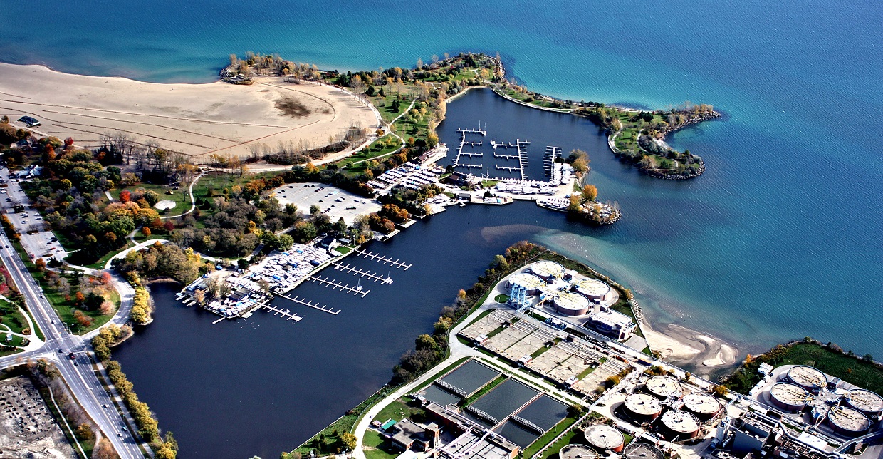
Ashbridges Bay on the north shore of Lake Ontario is a vibrant community with a host of land and water-based recreational opportunities for residents and visitors.
The purpose of the Ashbridges Bay Landform Project is to address the existing navigation risk caused by sediment accumulation at the harbour entrance of Coatsworth Cut, while considering approved projects and waterfront planning initiatives in the area, managing shoreline erosion along the northeast shore of Tommy Thompson Park, and providing enhancements to the aquatic habitat.
EXPLORE THE
ASHBRIDGES BAY LANDFORM PROJECT


STATUS REPORT
The first phase (Step 1) in the Ashbridges Bay Landform Project involved the completion and approval of the Ashbridges Bay Erosion and Sediment Control Class Environmental Assessment (EA) in 2015.
The EA was initiated by Toronto and Region Conservation Authority (TRCA), in partnership with the City of Toronto, in 2013 and sought to address the existing navigation risk caused by sediment disposition at the harbour entrance at Coatsworth Cut, while additionally considering approved projects and waterfront planning initiatives in the area.
The detailed design phase of the Project (Step 2) was undertaken and completed between 2017 and 2018, with the completion of permitting requirements still underway through early 2019.
Step 3 involves the initiation of the implementation phase. Project implementation formally began in January 2020, following the completion of partial site preparatory works in mid-2019.
Construction works are expected to be underway through to 2024.
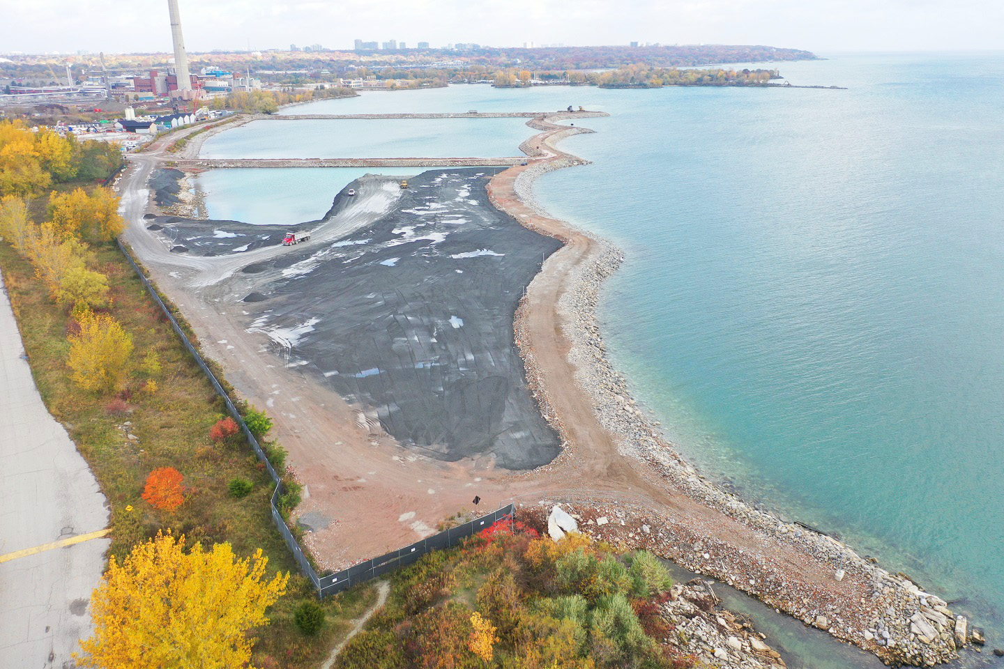
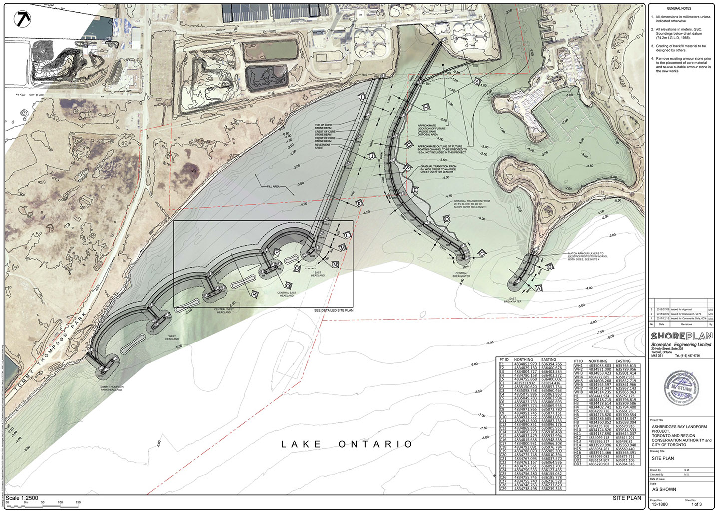
A phased approach to implementation is being undertaken, with the Landform being completed as three adjoining cells through land-based construction operations along the north-east shore of the Leslie Street Spit, directly adjacent to Tommy Thompson Park and the Ashbridges Bay Treatment Plant property.
The exterior berms for Cell 1 (the southernmost cell) and Cell 2 were closed in June and October 2020, respectively, and Cell 1 filling activities are currently underway.
Final site preparatory works are anticipated in early 2021 to facilitate the continued construction of the Cell 3 berm through to mid-2021, with implementation of the two headlands off of Cell 2 anticipated to commence in early 2021.
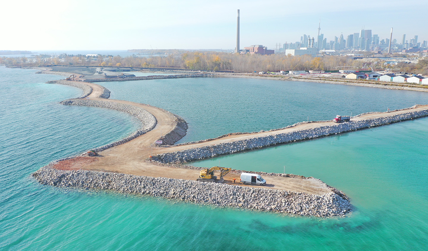
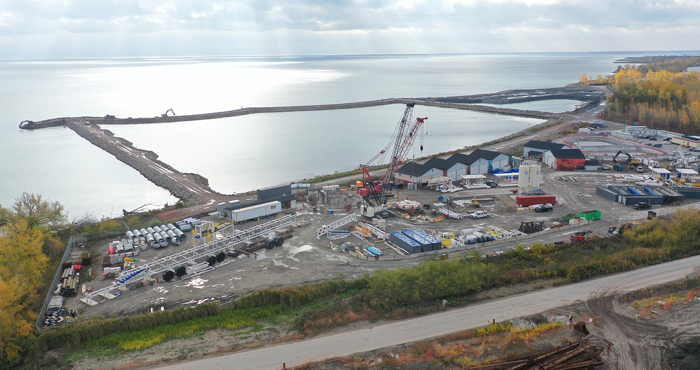
On the east side of the Bay, off the southernmost headland at Ashbridges Bay Park, construction of the Eastern Breakwater has been in progress since July 2020. This structure is slated for completion in December 2020, with Central Breakwater works currently scheduled to commence mid-2021.
These two features are being constructed exclusively by barge, and together will divert sediment away from the Coastworth Cut channel, promoting safe navigation and eliminated the need for dredging in the long term.
PROJECT BACKGROUND
TRCA, in partnership with the City of Toronto, re-initiated a Conservation Ontario Class EA to address erosion and sedimentation issues within Coatsworth Cut and Ashbridges Bay Park.
The 2013 EA picked up where the 2009 Class EA left off and identified the design alternatives that still remain valid given the change in project scope.
Two Public Information Centres were held to present and receive input on alternative solutions (June 19, 2013) and the recommended solution (February 6, 2014).
An Environmental Study Report (ESR) was completed (link below) and submitted for a 45-day public review period in December 2014. The ESR was subsequently approved in February 2015.
- Ashbridges Bay Class EA – Notice of Intent
- Ashbridges Bay Project Brief
- Ashbridges Bay Environmental Study Report
- Ashbridges Bay Environmental Study Report – Appendices
- Notice of Project Completion – Ashbridges Bay
A preferred alternative was identified through the Ashbridges Bay Erosion and Sediment Control Conservation Ontario Class EA process (April 2013–December 2014), consisting of erosion and sediment control structures to be integrated with the lakefill area required for the City’s planned stormwater and CSO treatment facilities that will form the Ashbridges Bay Landform.
This preferred alternative was subsequently refined through detailed design to remove any impacts to the existing outfall right-of-way.
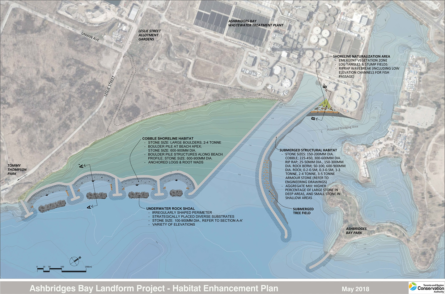
As part of the refined preferred alternative, a series of aquatic habitat enhancements are proposed. These include:
- Four submerged rock shoals within the headland-beach system
- Submerged rock piles, anchored log tangles and tree wads in the cobble beaches
- A shoreline naturalization area near the opening of Coatsworth Cut along the Central Breakwater
- Gravel fill along the inner bend of the Central Breakwater
- A vertical sunken tree field at the inner bend of the Central Breakwater
- Submerged rock berms along the Eastern Breakwater
The final design and proposed habitat enhancements are available for review below.
FINAL DESIGN
Download a Copy
HABITAT ENHANCEMENT PLAN
Download a Copy
STUDY AREA

Ashbridges Bay is located on the north shore of Lake Ontario in Toronto, Ontario. Within the local study area, Coatsworth Cut serves as an access route to the lake for several boat clubs, and a public boat launch, and offers sheltered water for sailing, kayaking, and canoeing.
Lands surrounding the local study area include Woodbine Beach, Ashbridge’s Bay Park, Tommy Thompson Park, and Toronto Water’s Ashbridges Bay Wastewater Treatment Plant.
BASELINE ENVIRONMENTAL INVENTORY
A draft Baseline Environmental Inventory (BEI) was prepared and was reviewed by Community Liaison Committee members in November 2013.
The project BEI consists of the examination and documentation of existing project site conditions: physical, biological, cultural and socio-economic environments. The physical environment description includes an account of previous measures (dredging) implemented in the area and technical and engineering aspects to be considered.
The report provides the baseline conditions information needed to evaluate alternative methods of addressing the problem situation. In addition, the inventory provides a baseline from which to monitor the effectiveness of the action, once taken, as well as the types and levels of environmental impacts.
PUBLIC AND AGENCY CONSULTATION
The Class EA process provides that all views respecting a proposed remedial flood or erosion control project be taken into consideration during the planning and design of remedial flood and erosion control projects.
A Community Liaison Committee (CLC) was formed to provide a venue to allow concerned citizens, local interest groups and non-governmental organizations to voice issues of public concern as well as assist in the planning and design process of the project.
Public Information Centres (PICs) were also held to seek feedback on the study from a broad audience.
Community Liaison Committee
A Community Liaison Committee (CLC) was established subsequently to publishing the project Notice of Intent. The CLC met three times throughout the course of the EA. Presentations and minutes associated with these meetings are available below.
CLC Meeting #1 – May 15, 2013
CLC Meeting #2 – September 5, 2013
CLC Meeting #3 – November 28, 2013
Public Information Centres
Two Public Information Centres (PICs) were held to allow for public comment on the EA. These public meetings provided opportunities for the community to be made aware of the project and provide feedback as the study progressed.
Both PICs were advertised in the Beach Mirror newspaper prior to the meeting and notices were sent to project stakeholders (CLC members, politicians and others who expressed interest in the project) electronically.
Public Information Centre #1
The first Public Information Centre (PIC) was held on Wednesday June 19, 2013 from 6:30 pm to 8:30 pm at the Toronto Fire Academy (895 Eastern Ave, Toronto). Background information on the project was provided and the public were asked to provide feedback on the draft evaluation criteria that will be used to assess remedial alternatives.
24 Panels were featured at the PIC outlining the project process, existing conditions, screening of previous remedial alternatives, draft evaluation criteria and next steps. A comment form (workbook) was provided at the PIC and also made available online. Comments and feedback were requested to be submitted during the two weeks following the meeting.
- PIC #1 Panels
- PIC #1 Workbook
- Meeting Notice: NOTICE For PIC 1 – Ashbridges Bay Class EA
Public Information Centre #2
The second PIC was held on February 6, 2014 from 6:30 pm to 8:30 pm at the Toronto Fire Academy (895 Eastern Ave, Toronto). The purpose of this PIC was to review the results of alternatives evaluation and present the recommended preferred alternative.
Similar to the first PIC, a comment form (workbook) was provided at the PIC and also made available online. Comments and feedback were requested to be submitted during the two weeks following the meeting.
- PIC 2 Panels
- Project context map – showing the Preliminary Preferred Alternative along with other City of Toronto Approved Facilities
- PIC 2 Comment Form
- Meeting Notice: Ashbridges Bay EA Notice of PIC 2
CONTACT US
Ashbridges Bay Landform Project Team
ABTP.Landform@trca.ca