Toronto and Region Conservation Authority (TRCA), in partnership with the City of Pickering, has completed the construction of erosion control works within Amberlea Creek (Vistula Ravine) and abutment protection works at the existing pedestrian bridge. Construction started in the winter of 2014 and was completed in the summer of 2015.
Project Update:
TRCA staff will be on site until spring of 2016 to complete site restoration work including plantings and habitat features, as weather conditions permit.
Contact Us:
Natalie Seniuk, Project Manager, Toronto and Region Conservation Authority (TRCA), 416.661.6600 ext. 5655 or nseniuk@trca.on.ca
Photographs of Project Site
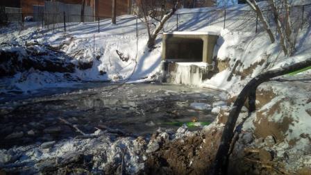
Amberlea Creek Project Site Before Construction
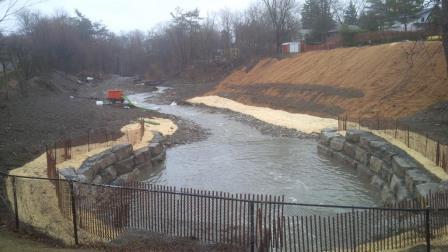
Amberlea Creek Project Site During Construction
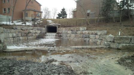
Amberlea Creek Project Site After Construction

Background of Project
In 2006, the City of Pickering formally retained Marshall Macklin Monaghan Ltd. to develop a Stormwater Management Master Plan (Master Plan) for Frenchman’s Bay. The Master Plan was “to address long-standing concerns regarding the ongoing decline in the quality of the Frenchman’s Bay ecosystem by seeking means to control the quantity and quality of storm run-off entering the local creeks and the Bay itself” (City of Pickering, 2006). The Master Plan was finalized in 2007, and there were a series of recommendations and projects to address public safety issues and degraded water quality within Frenchman’s Bay and four main tributary watersheds. The Master Plan proposed a phased approach for dealing with key priority sites over the first five years of the implementation of the plan.
One of the key projects identified for completion within Phase 1 of the Master Plan is the undertaking of the Amberlea Creek Erosion Control Environmental Assessment (Amberlea Creek EA). Amberlea Creek is one of the four main tributaries of Frenchman’s Bay, located northwest of the Bay. The project will assess opportunities for the entire watershed, however specific focus will be on the last 600 metres (m) of open channel before Amberlea empties into Frenchman’s Bay, an area of the watershed where existing valley wall, (slope) instability, and channel erosion is occurring.
Project Purpose
The purpose of the Amberlea Creek Project was to provide long-term protection against slope instability, and channel erosion that will reduce the risk to public safety, and prevent future property damage.
Planning Mechanism for the Undertaking
TRCA must conduct its remedial flood and erosion control projects in accordance with the Environmental Assessment Act (EAA). Recognizing that common elements exist in addressing flood and erosion problems, a more efficient approach to environmental assessment was developed by Conservation Ontario for all conservation authorities known as the Class Environmental Assessment for Remedial Flood and Erosion Control Projects (Class EA). The Class EA approach was considered a suitable means for the planning of remedial flood and erosion control projects because it provided a consistent, streamlined process that ensured compliance with Environmental Assessment Act (EAA) requirements.
The planning phase of this project was carried out under the Class EA process identified above. An Environmental Study Report (ESR) was filed with the Ministry of Environment (MOE) on August 21, 2013 and approval of the Environmental Assessment was received from the Minister’s office on February 3, 2014, allowing the project to be implemented as planned.
Public and Agency Consultation
During the Class EA a Community Liaison Committee (CLC) was formed to provide a venue to allow concerned citizens, local interest groups, and non-governmental organization to voice issues of public concern as well as assist in the planning and design process of the project. The CLC was an integral part of the Class EA process, assisting with the evaluation of the alternatives and the selection of the preferred alternative. In addition to the CLC, two (2) Public Information Centres (PICs) were held to provide broader public input into the planning and evaluation process for the Project.