Toronto and Region Conservation Authority (TRCA) has formally commenced Conservation Ontario’s Class Environmental Assessment for the Denison Road West Upper Slope Stabilization Project, in the City of Toronto.
Project Location
The study area is located southwest of the intersection of Lawrence Avenue West and Jane Street, in the City of Toronto. Residential properties on Denison Road West back onto the crest of a steep valley slope along the Humber River. Four properties and a TRCA-owned public parkette which are situated near Raymore Park make up the study area.
Learn More About the Project


Project Background
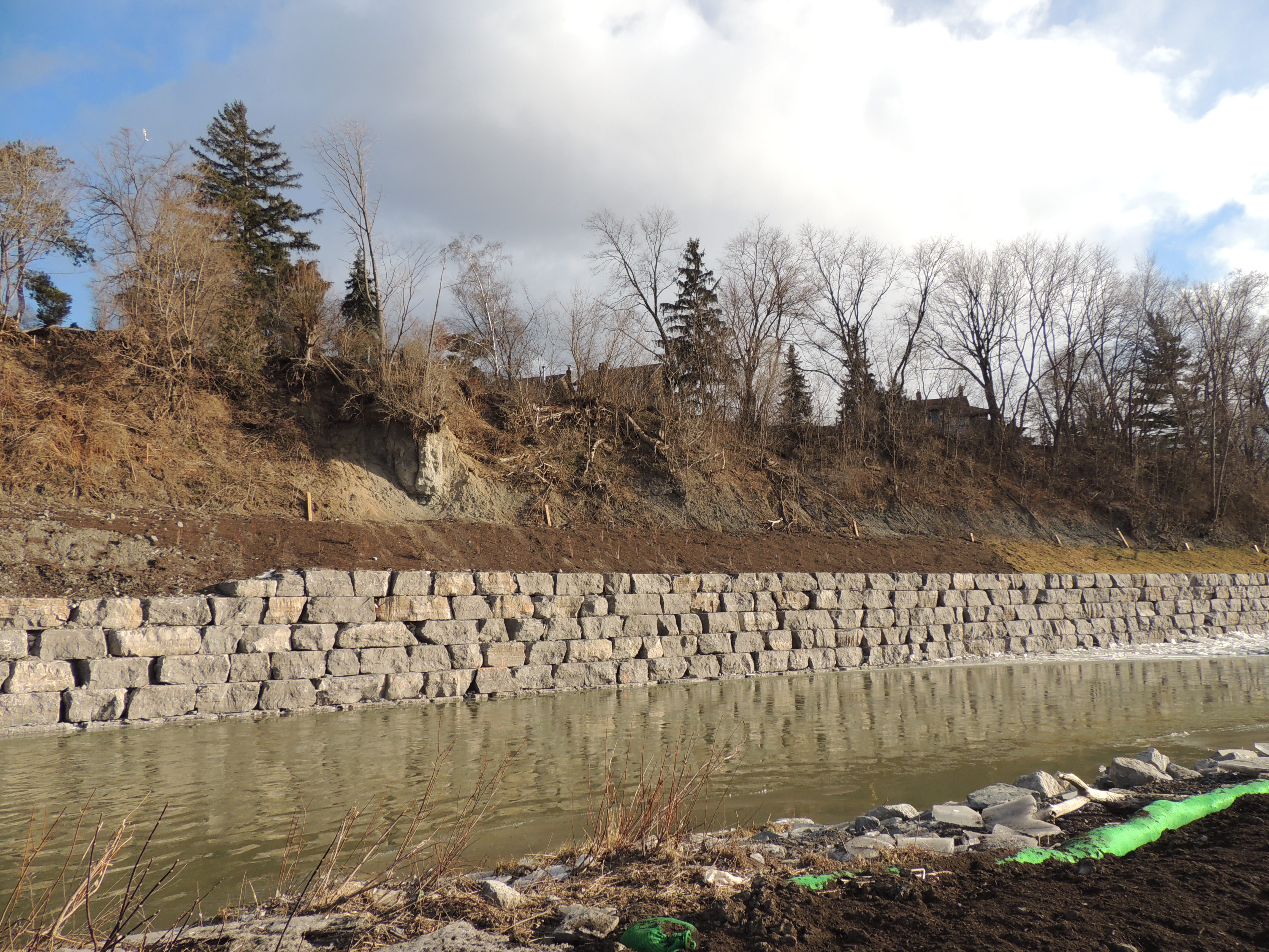
The Humber River is a large, fast-moving watercourse which has the potential to cause major changes to the surrounding landscape. TRCA has been monitoring this area since the early 1980s due to its known erosion risks. At that time, TRCA constructed a 350 metre long revetment along the eastern valley wall below Denison Road West. The intent of the project was to stabilize the bank of the river and provide support to the slope above it.
Following a major storm event in August 2005, high water levels topped the revetment, causing instability in the slope above. In response, TRCA retained Golder Associates to carry out a thorough slope stability review. Completed in 2009, their review found that the slope was unstable and the residences near the top of the slope were at risk, if failure were to occur.
In 2015, TRCA subsequently retained Terraprobe to carry out subsurface investigations and develop detailed designs. Designs were developed to address the lower slope instability where erosion risk from the Humber River was greatest. TRCA’s preferred design included replacing the failed revetment with an armourstone wall and regrading the slope directly above it.
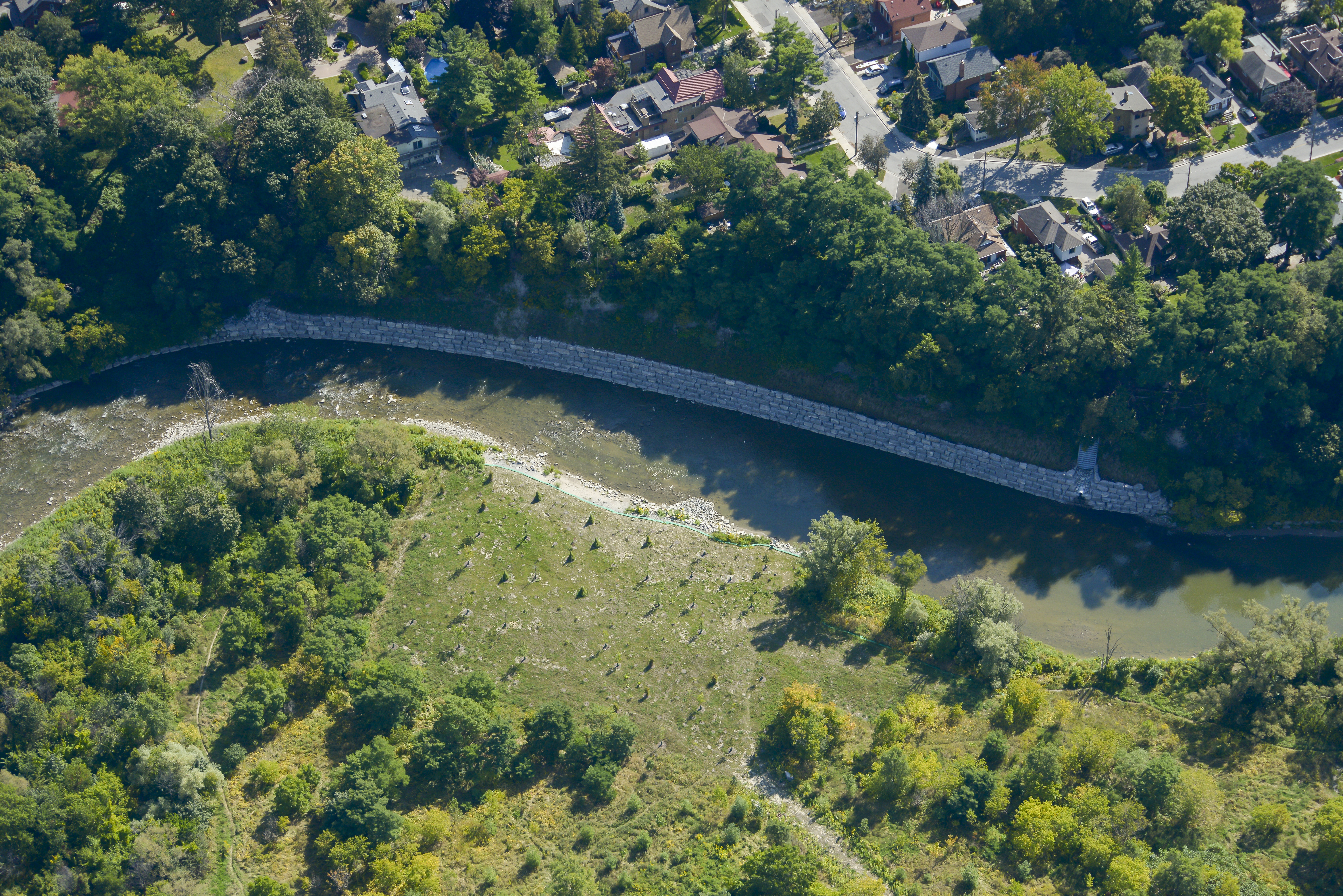
In 2017, TRCA completed construction of the wall designed by Terraprobe and planted native shrub species above the wall to further stabilize the ground.
The Current Class EA Study
The lower slope work completed in 2017 was the first phase in addressing the risk of future slope failure. TRCA is commencing a second phase of work which will investigate possible measures to address upper slope instability. The current study focuses on four private properties as well as a parkette located above the existing wall. The project plans to implement a continuous treatment across all five at-risk properties. This is the most effective way to provide a long-term, low maintenance solution for slope stabilization.
This project is being planned in accordance with Conservation Ontario’s Class Environmental Assessment for Remedial Flood and Erosion Control Projects (amended 2013), which is the approved process for this type of undertaking. TRCA invites residents of the community to participate in this study, through public and stakeholder engagement. Public input is a fundamental part of the planning and design process for this project. To learn more about the public consultation elements of a Class EA project, see here. For a general overview of EAs, see here.
Scope of Work
As part of this study, the geotechnical investigation will determine the cause and extent of slope instability. These factors help TRCA’s consultant develop alternative solutions in order to address risk to public and private property. TRCA then evaluates each alternative and engages the public in selecting the preferred solution. The preferred alternative is presented in a Project Plan, and considered final following a 30-day public review period. TRCA can then proceed with selecting a consultant to develop detailed designs based on the preferred alternative. The final design will then be implemented in order to provide long-term protection for essential structures at the top of the slope.
Currently, TRCA’s geotechnical consultant is in the process of analyzing the information collected during their investigation. The consultant will then develop a selection of conceptual solutions to address slope instability. TRCA will be coordinating opportunities for public engagement in the evaluation of the alternative concepts in 2020.
Construction Information
Construction planning will begin once a preferred alternative has been selected and detailed designs are underway. The construction phase of the work is also tentatively planned for late 2020 or early 2021.
Public Consultation
The Conservation Ontario Class Environmental Assessment for Remedial Flood and Erosion Control Projects is being used to conduct this study. In previously developed areas, Conservation Authorities have approval to use this assessment process for projects that will protect human life and property from potential flood or erosion problems. The Class EA process outlines the steps required to determine the best solution for addressing erosion hazards. Several alternative solutions are considered for a project under the Class EA. Each alternative undergoes detailed technical evaluation as well as public review and consultation. Finally, this review process identifies a preferred alternative. The preferred alternative offers the best means to protect against flooding and erosion. It also mitigates other environmental effects which could result from the project.
Additionally, the Conservation Authority Class EA process guarantees opportunities for public and stakeholder participation throughout the planning stages of a project. TRCA will coordinate these consultation opportunities, and then post updates and scheduled meetings to this web page.
Figure 1 shows the project planning process, which follows Class EA requirements.
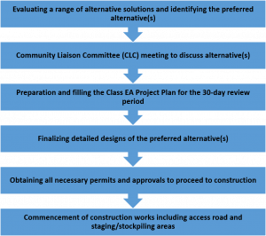 Figure 1. Class Environmental Assessment process.
EA Documents
Project Updates
November 2019
TRCA’s geotechnical consultant performed investigative work on all properties participating in the project. They advanced boreholes along the length of the study area over three days of drilling work. TRCA uses investigations like this because they determine the long term stability of the slope. They also help predict which structures may be at risk due to future erosion.

October 2019
TRCA is currently in the process of scheduling slope stability assessments with the geotechnical engineering consultant for the project. Additionally, this consultant will also develop design concepts for slope stabilization works.
Contact Us
For more information about this project, please contact:
Nivedha Sundararajah, Project Manager, Erosion Risk Management
Toronto and Region Conservation Authority
Email: nivedha.sundararajah@trca.ca
Phone: (416) 661-6600