Toronto and Region Conservation Authority’s (TRCA) Environmental Monitoring & Data Management team undertake special short-term environmental monitoring projects to assess the ecological health of the regional watersheds and the Toronto waterfront.
Asian Carp Surveillance
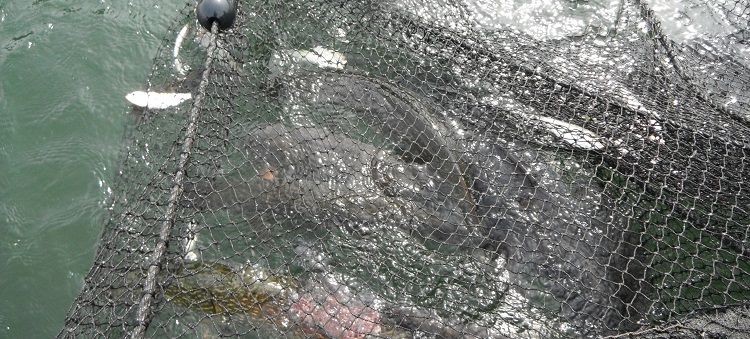
During 2015 routine coastal fisheries surveys, TRCA discovered five Asian Carp in Toronto Harbour. Like many invasive species, these adaptive fish are capable of producing many offspring, can outcompete native fishes for food and habitat, and have few native predators to keep their populations in check. They can also act as carriers for diseases or parasites that could spread to native fishes.
To prevent the establishment of Asian Carp in Greater Toronto Area waters, TRCA has been actively surveying the Toronto regional waterfront since 2016 in partnership with Fisheries and Oceans Canada, and with support from the RBC Blue Water Project. No additional Asian Carp have been found since the initial discoveries of five Asian Grass Carp during the summer of 2015.
If you have seen an Asian carp or other invasive species please contact Ontario’s Invading Species Hotline (toll-free) 1-800-563-7711 or report it online at EDD MapS Ontario.
ASIAN CARP: WHAT YOU NEED TO KNOW!
Sea Lamprey
Since 2005, TRCA has worked in contract partnership with Fisheries and Oceans Canada (DFO) to collect sea lamprey during their spawning season (mid-April to mid-June) in an effort to reduce their impact on fish communities within Lake Ontario. There are traps built into the first weirs of the Humber River and Duffins Creek, with the intent of capturing the adult sea lamprey as they migrate upstream to spawn. In 2020, TRCA monitoring crews caught 848 invasive Sea Lamprey in the Humber River trap and 115 in the Duffins Creek Trap.
Sea lamprey are an invasive parasitic fish native to the Atlantic Ocean that voraciously feed on the bodily fluids of other fish using their suction cup mouth lined with teeth. The first reported occurrence of sea lamprey in the Great Lakes was in the 1830’s and it is believed that they entered the Great Lakes through the shipping channels. In the 1940’s and 50’s sea lamprey had a significant role in the collapse of the lake trout and whitefish fisheries, which have both been historic economic mainstays of the Great Lakes fishery.
TRCA continues to work with outside agencies that have a collaborative interest in fish community health for the benefit of not only TRCA’s jurisdiction but the Great Lakes Region overall.
Fisher Study
From 2014 to 2018, four den boxes were set up in Glen Major Forest by TRCA for the purpose of studying the number and sex of fishers inhabiting Glen Major Forest, as well as their genetic profile in relation to neighbouring populations. The den boxes were baited to attract female fishers to move in, have their kits and rear their young. The boxes were a new approach to monitoring local fisher populations, having had limited success with just baited hair snare stations in the past. Each den box was equipped with a logging instrument to monitor internal temperatures, and a sticky pad was placed at the top of the entrance hole to collect hair samples for genetic profiling. Motion activated trail cameras were also attached to trees opposite each box to capture images of animals trying to access them. Even though fishers’ were captured on camera investigating the den boxes, no evidence could be found that female fishers occupied them to rear their young and the study concluded in 2018.
Acoustic Telemetry
2020 marks the tenth year the Acoustic Telemetry research study has been underway. Thanks to this ‘high-tech’ fish tagging study, resource managers are learning how fish are using restored habitats in order to enhance or expand restoration efforts throughout the Toronto Harbour. In partnership with researchers from Carleton University and the Department of Fisheries and Oceans Canada, environmental monitoring crews from TRCA have tagged over 500 native and non-native fish with acoustic transmitters since 2010, in an effort to track their feeding and spawning activities 24 hours a day year-round.
Understanding the mysteries of fish behavior, including where and how long fish are spawning and feeding throughout the seasons, will help TRCA continue to manage aquatic habitat along Toronto’s waterfront. The goal is to support a community of desirable native fish species as well as a self-sustaining fishery. Future plans for the project include expanding the study area to pick up acoustic signals from tagged fish travelling along the north shore of Lake Ontario. This information will help to answer questions about how fish move regionally and how agencies can work together to improve the health of Lake Ontario.
Seaton Development Lands
The Central Pickering Development Plan outlines the blueprint for a new urban community of up to 70,000 people and 35,000 jobs, along with a designated agricultural preserve on the west side of Duffins Creek. The Seaton project is unique because 53% or 1,520 ha of the planning area is designated as a Natural Heritage System (NHS) and will be retained in public ownership.
Due to the size and scale of this development, its sustainability aspects and the sensitivity of the nearby ecosystems, TRCA initiated a large-scale monitoring program in 2014 to evaluate the natural heritage of the Seaton development lands. TRCA will be monitoring both the aquatic and terrestrial ecosystem (pre, during, and post development) to determine if the sustainability practices and the large natural heritage system are sufficient to protect the ecological integrity of the sensitive natural heritage features within the project boundaries. For example, the Seaton development lands are home to important local populations of the provincially endangered Redside Dace as well as the sensitive Brook Trout, which is the only remaining native Salmonid fish species naturally occurring in headwater sections of the Humber, Rouge, and Duffins watersheds.
Currently there are long-term monitoring plots set-up to track changes in vegetation and bird communities, as well as aquatic sites to monitor fish and benthic macroinvertebrate communities. Conductivity loggers, used to estimate chloride concentrations, as well as year-round temperature and water quality monitoring stations are also in place. Results from this monitoring program are expected to largely influence future planning decisions regarding the Seaton development lands and potentially future development activities in other TRCA watersheds.
Nearshore Community Index Netting
Funded by the Canada-Ontario Agreement (COA), TRCA under contract by the Ontario Ministry of Natural Resources and Forestry (OMNRF) are involved in nearshore fish community identification and assessments at 24 sites along the Toronto regional waterfront. Nearshore Community Index Netting (NSCIN) is an over-night netting program designed to evaluate abundance and other attributes (e.g. length, weight, age) of fish species that inhabit that littoral (i.e. close to shore) zone of Ontario lakes. The project follows the OMNRF’s NSCIN guidelines. To date, NSCIN trap netting has been conducted along the Toronto regional waterfront in 2006, 2007, 2010, 2012, 2016 and 2018.
These nearshore fisheries surveys add to the knowledge gained through TRCA’s annual coastal fisheries surveys, which have been on-going since the 1960s in support of Toronto & Region’s Remedial Action Plan (RAP).