![]()
Nine conservation authorities across the Oak Ridges Moraine (ORM) joined together in 2000 as the Conservation Authorities Moraine Coalition (CAMC) to advocate for and protect the moraine along its 160-kilometre length. The CAMC was formed in response to the need for a comprehensive policy, planning and management approach geared to sustaining the health of the entire Oak Ridges Moraine.
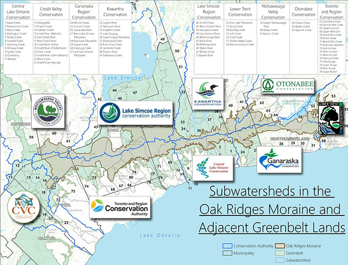
The watershed boundaries of the nine independent conservation authorities – CENTRAL LAKE ONTARIO, CREDIT VALLEY, GANARASKA, KAWARTHA, LAKE SIMCOE REGION, LOWER TRENT, NOTTAWASAGA VALLEY, OTONABEE, TORONTO AND REGION – collectively cover the entire moraine. Together, as of 2012, the conservation authorities own more than 14,000 hectares of public lands on the Moraine. This makes them responsible for the management of the largest and most strategically located tracts of land protecting the headwaters of the 65 river systems originating on the Moraine. These lands include both environmentally significant and publicly accessible recreational lands such as the Ganaraska Forest Centre, Fleetwood Creek Natural Area and Purple Woods, Thornton Bales and Albion Hills conservation parks.
Map of Oak Ridges Moraine and conservation authority watershed boundaries:
The CAMC is a partnership organization, collaborating with numerous groups and individuals to achieve our common objectives for healthy headwaters, education and sustainable living on the Oak Ridges Moraine. The activities of the CAMC and links to some of our partnership projects are shown below.
Report Card on The Environmental Health of the Oak Ridges Moraine and The Adjacent Greenbelt Lands
The Report Card reveals that efforts to protect the Oak Ridges Moraine (ORM) have been successful in safeguarding existing forests, aquatic habitat, and groundwater the region’s residents rely on. However, the report also identifies that further work is vital to ensure the preservation of this significant natural heritage landscape.
- Click here for the TRCA report card
- Visit the Conservation Authorities Moraine Coalition website for more details.
The nine individual Conservation Authorities of the CAMC :
Providing coordinated and effective scientific expertise in the undertaking of watershed plans and watershed stewardship services as well as our traditional role of providing environmental planning advisory services to municipalities (see Links above).
- CAMC 2012 Accomplishments
- CAMC Strategic Plan 2011 – 2020
- CAMC 2011 Accomplishments
- CAMC 2010 Accomplishments
- CAMC 2009 Accomplishments
- CAMC 2008 Accomplishments
- CAMC 2007 Accomplishments
- CAMC 2006 Accomplishments
- CAMC 2005 Accomplishments
- CAMC 2004 Accomplishments
- ORM Conservation Plan at OMB
- CAMC Mission, Goals, Accomplishments & Implementation Challenges
Municipal, provincial and federal governments:
- The study and management of groundwater resources
YPDT-CAMC Groundwater Study Website
YPDT-CAMC Groundwater Program Brochure - Oak Ridges Moraine Conservation Plan, Maps, Technical Implementation Guidelines and general information
- Watershed Planning – from Recommendations to Municipal Policies – a Guidance Document
- The Greenbelt
Non-government organizations with major projects on the ORM:
- End to end Moraine Trail System
- Land Acquisition and Conservation Easements
- Tall Grass Prairie and Savannah Restoration – Rice Lake Plains
- Save the Oak Ridges Moraine Coalition
- Measuring Success on the Oak Ridges Moraine – Watershed Health Assessment
For further information on the Conservation Authorities Moraine Coalition contact:
CAMC 2015 Chair
Mike Walters
CAO
Lake Simcoe Region Conservation
905-895-1281
m.walters@lsrca.on.ca
Groundwater,
Steve Holysh
CAMC Chief Hydrogeologist,
Toronto and Region Conservation
416-661-6600 ext. 5588
sholysh@trca.on.ca
Planning, Policy & General Info,
David Burnett, CAMC Coordinator
Senior Manager, Regional & Provincial Policy,
Toronto and Region Conservation
416-661-6600 ext.5361
dburnett@trca.on.ca